


17-Mile Drive - Stop by Stop Guide to Monterey’s Famous Scenic Coastal Route

17-Mile Drive is one of the most famous scenic drives in California. Stretching through the exclusive community of Pebble Beach on the Monterey Peninsula, this 17-stop route takes you through the Del Monte Forest along a winding coastal road as you pass windswept beaches, gaze upon towering Monterey Cypress trees, take in incredible ocean overlooks, and enjoy some of the most beautiful coastal landscapes in California. There’s also more than just epic nature to be found here - as you drive the route, you’ll pass by dozens of eye-popping luxurious estates and the world-renowned golf course, Pebble Beach Golf Links. In this post, I’ll cover everything you need to know to plan and make the most of your visit to 17-Mile Drive. By the end of this post you’ll be ready to hit the road and discover for yourself what makes 17-Mile Drive such an unforgettable experience!

Location - Where is 17-Mile Drive?
17-Mile Drive is located on the Monterey Peninsula, on California’s central coast. It’s about 120 miles south of San Francisco and 300 miles north of Los Angeles.
A Brief History of Monterey’s 17-Mile Drive
17-Mile Drive dates back to the 1880s, when wealthy tourists staying at the luxurious Hotel Del Monte would use horse-drawn carriages to enjoy the local coastline. The official scenic carriage route of this era became the foundation of the road our cars drive on today. As the century turned, tourism continued to flourish in the area, and in 1919 Pebble Beach Golf Links opened. This would become one of the most famous golf courses on earth. Today, 17-Mile Drive is famous for both the incredible scenery and the world renowned Pebble Beach golf scene.

Planning Your Visit & Tips to Make the Most of Your Drive
Entrances & Fees
17-Mile Drive is a privately operated toll road, so there is a small fee to enter. As of November 2026, the entrance fee is $12.50 per vehicle for day visitors. Cars only, motorcycles are not permitted. If you spend a minimum of $35 at one of the Pebble Beach Resort restaurants (excluding Pebble Beach Market), the entrance fee is reimbursable, so do keep the entry receipt if you plan to dine at one of the resort spots. Tour buses are also permitted on 17-Mile Drive, at a cost of $6 per passenger. If you’re an overnight guest at one of the on-site resort accommodations - The Lodge at Pebble Beach, The Inn at Spanish Bay or Casa Palmero - then admission to the road is free.

There are 5 entrance gates to 17-Mile Drive. You can use whichever is most convenient to you. If you're coming from Monterey, the Highway 1 gate is a good choice, as this will put your entry very close to stop 1 on the map. If you're coming from the Carmel area, the Carmel gate puts you on the road in between stops 15/16 and 17. Full list of entrance gates:
Pacific Grove Gate
Country Club Gate
SFB Morse Gate
Highway 1 Gate
Carmel Gate
At each entrance you can pick up a complimentary map - don’t forget to grab one! Maybe I'm just old, but I found having the paper copy was really convenient for navigating around. The scenic tour itself isn’t too hard to navigate though, you simply follow the red-dotted line.

About the Drive
The drive itself is (not surprisingly) a loop of about 17 miles long (27 km). You’ll definitely want to stop along the way though, as this is a route that is designed for visitors to get out of the car and explore a bit on foot. There are 17 stops along the scenic tour. Stops are well labeled with signage on the main road, and there are parking lots at each.

The stops all have names and are also numbered 1 - 17, and you can do them in any order you’d like. We didn’t actually do them in numerical order - we entered at the north end of the drive from the Pacific Grove gate, so our first stop was #3. We then headed south along the coastline, before looping back up north to finish with stops 17, 1, and 2.

Many of the stops are along the coast, but there are a few inland ones. Some visitors skip over these, but they’re also quite lovely in their own right, so don’t forget about them! Each stop also has informational signage on site, telling you a little about where you are and what the history is. I’ll go over each individual stop and what you can expect to see there in a bit.

When to Go
The drive can generally be done any time of the year, and the route is open from sunrise to sunset. I’d say the best time of year to go would be spring or fall, but do note that 2 of the stops are closed annually from April 1 - June 1. Winter can be cold, windy and rainy for walking around outside, and summertime can occasionally bring in fog that obstructs views.
As with most tourist activities, avoiding weekends and holidays is always best for lower crowd sizes, and if you want to have the viewpoints as empty as possible, go early in the morning right after sunrise - this is also a great time of the day for photography!

Do note that 17-Mile Drive is not guaranteed to be open every day of the year. It does occasionally close to the general public, usually because of major events in Pebble Beach, as this area hosts several large automotive and golf events throughout the year. There will also be times where a major event will be taking place and the drive will remain open, albeit with restricted access or significant traffic controls. Be sure to check the official Pebble Beach 17-Mile Drive information page before you visit for the most up to date information.

Some closure events to be aware of:
Pebble Beach Concours d’Elegance: This is an annual event, and during Concours weekend, access is restricted for tourist traffic. Only event attendees, residents, and authorized visitors may still enter. The 2027 weekend is scheduled for August 12–15.
AT&T Pebble Beach Pro-Am: This is an annual professional golf tournament that brings enormous crowds to the area. The drive may remain open, but traffic restrictions, special access arrangements, and temporary closures will likely affect general sightseeing visitors. The 2027 dates are February 1 - 7.
2027 US Open Championship: This will take place June 14 - 20. No official closure information has been released as of this blog’s posting, but when Pebble Beach last hosted the US Open in 2019, 17-Mile Drive was closed to tourist traffic. I would strongly recommend planning your sightseeing visit for a different week unless Pebble Beach confirms public access.
Road Maintenance or Emergencies: Always keep this one on your radar. The Monterey Peninsula is an area with very dynamic weather, and road sections may occasionally close due to construction, dangerous conditions, or other safety concerns.

How Long to Spend Here
The drive itself isn’t very long, so how much time you can expect to spend completing the route can vary. If you zip through with just popping out of the car briefly at the main stops, you can be done in an hour. Most visitors go through in about 2 - 3 hours, which gives you time to see the stops and take a few short walks. If you really want to take your time to explore and give both your legs and camera some exercise, then plan on closer to half a day - that’s about how long we spent here.

Facilities & Food Along the Route
There are restrooms located near stop 7 and at stop 14.
There are quite a few options for food along 17-Mile Drive, but most are concentrated at two locations: The Inn at Spanish Bay and The Lodge at Pebble Beach. Remember to show your entrance receipt for reimbursement if you eat any of the restaurants.
The Inn at Spanish Bay is located at the north end of the drive, near the Pacific Grove gate. There are several options here. Some will require reservations, which can be booked by calling the reservations line at (855) 421-0255 or online:
Roy's at Pebble Beach: Hawaiian-fusion cuisine with a beautiful setting overlooking Spanish Bay. Open for breakfast, lunch and dinner.
Pèppoli at Pebble Beach: Italian and Tuscan-inspired food. Dinner only.
Traps: A lounge with hearty appetizers, open 11 am - midnight.
The Lobby Lounge: Light bites and drinks with outdoor fire pits, available from 6 am - 10 pm daily.
Sticks: Contemporary sports bar food. Currently closed for renovations, scheduled to reopen on March 1, 2027.
Stave Wine Cellar at Spanish Bay: Wine tastings and small bites from 2 pm - 9 pm.
The Lodge at Pebble Beach is located on the southern end of the drive, near Pebble Beach Golf Links. As with The Inn restaurants, some of these will require reservations, which can be booked by calling the reservations line at (855) 421-0255 or online:
Stillwater: Upscale California coastal cuisine with beautiful ocean views. Open for breakfast, lunch, and dinner.
Tap Room: Traditional American steakhouse in a historic golf atmosphere. Open 11 am – 11:30 pm.
The Bench: Wood-fired & artisanal specialties, open from 11 am - 9 pm.
Hay's Place: Mexican-inspired food in a more relaxed setting, with outdoor seating and views. Open for lunch and dinner.
Gallery Café: Casual café serving breakfast and lunch, open 6 am - 2 pm.
Terrace Lounge: Golf course views and a specialty Stillwater menu. Open daily for lunch and dinner.
Pebble Beach Market: This is the only spot for grab-and-go food. It’s right outside The Lodge at Pebble Beach. Here you’ll find made-to-order deli sandwiches, gourmet snacks, salads, desserts, and some general grocery items. Open daily 7:30 am - 7 pm.

There are a couple of other places to pick up food as well:
The Beach Club Dining Room: Seafood & traditional American cuisine with views of the 17th fairway of Pebble Beach Golf Links. This restaurant is only open to members or those staying at a Pebble Beach resort.
Spyglass Hill: Informal dining next to the 9th green at Spyglass Hill Golf Course. Open from 6 am – 5 pm daily.
Self-catering is also a great option while enjoying 17-Mile Drive. There are picnic tables located throughout the coastal portion of the drive, many with unbeatable ocean views. You can pick up your own food before you start your day, or else stop at the Pebble Beach Market and get a picnic lunch to-go!

Weather
The Monterey Peninsula has a well-earned reputation for unpredictable coastal weather. Don’t be surprised if you leave your Monterey or Carmel hotel in the sunshine and arrive to a 17-Mile Drive covered in fog. A foggy start can still turn into a beautiful day though! Conditions here change quickly, so be prepared for anything and always bring a jacket or layers - even in the summer. I visited in early May and wore a pretty heavy jacket over a hoodie most of the day.

Local Wildlife
One thing I regretted was not bringing binoculars, especially for all the coastal overlooks! One of the most enjoyable things about 17-Mile Drive is the wildlife, but animals can appear pretty far off into the distance. Depending on the time of year, you can potentially spot sea otters, harbor seals, California sea lions, pelicans, gulls, and whales. For the whale fans in particular - I'll quickly mention here that Monterey is a fabulous place to go on whale watching boat tours. We did an 8-hour tour while we were in the area, and it was one of my favorite experiences ever!

Safety & Rules
Always remember that this is a privately operated road, and not an unrestricted public highway. You’ll have to follow a few rules, which are highlighted below:
Only stop in designated parking areas and pullouts. The drive is set up with exploring on foot in mind, so there will be plenty of official spots to park in. Don’t create your own.
Don't stop on the roadway to take photographs.
Observe posted speed limits.
Drones are prohibited.
As you go through, you’ll not only take in some of the best coastal scenery California has to offer, but you’ll also get to gawk at some of the state’s most luxurious homes. Remember to respect private property and keep out of residential areas. This is a tourist drive, but people do also live here.
The Pacific Ocean can be very dangerous. Waves can arrive unexpectedly and smash up onto rocks, even when the water seems relatively calm. Avoid climbing onto exposed rocks near waves or wading into areas with potentially strong surf and currents. Use good judgement and enjoy the coastline from safe distances.

Guide to 17-Mile Drive, Stop by Stop
I noted above that we explored a bit out of order, but ’ll go in order of the stops here, starting with 1 and ending with 17. Let's get to it!
Stop 1 - Shepherd’s Knoll
The first stop is an inland one. It’s an elevated overlook tucked into the Del Monte Forest, offering views looking down into the valley and north across Monterey Bay. Shepherd’s Knoll is named for a local railroad businessman who helped develop the early scenic tourist roads through the forest.

Stop 2 - Huckleberry Hill
This is one of the highest points along 17-Mile Drive, sitting approximately 800 feet (244 m) above sea level. The hill gets its name from the wild huckleberry bushes that grow throughout this part of the Del Monte Forest. The tree-top level overlook is lovely, and on a clear day you may be able to see all the way to Santa Cruz! We took a few minutes here to walk down into the forest.

Stop 3 - Spanish Bay Beach
This is the first oceanside stop on the map, and what a thrilling start! Spanish Bay is named for the Spanish explorers who spent time here in the 1760s. It features a long, broad beach and lovely natural scenery. We went for a lovely walk here, climbing down the rocks and strolling across the open sand.

Stop 4 - The Restless Sea
The Restless Sea is named for the ocean’s behavior here. Due to submerged rocks, waves are constantly crashing into each other at this spot, making it one of most turbulent sections of coastline in the area. Unsurprisingly, there is a fence here that prohibits visitors from getting too close to the water.

Stop 5 - Point Joe
The history of the name at this stop is kind of funny - In the early 1900s, a man named Joe lived here in a driftwood hut, earning a living as a goat herder and by selling souvenirs to tourists. Apparently no one really remembers though if Joe was named for the point, or the point was named for Joe. In any case, it’s another beautiful lookout on the ocean, full of pink flowers during my visit in early May. As with the Restless Sea, it is fenced off to prohibit climbing out onto the potentially hazardous rocks.

Stop 6 - China Rock
This spot is named for the small Chinese fishing village that existed here in the late 1800s. This stop is safer for walking around, so we were able to walk up onto some high rocks to take photos of the sweeping California coastal scenery.

Stop 7 - Bird Rock
This stop is one of my favorites because it is so jam packed with wildlife! You’ll definitely want the binoculars here. Bird Rock is named for the large offshore rock that attracts seabirds, harbor seals, and California sea lions. During our visit, marine mammals were seemingly everywhere we looked around here - it’s such an epic spot for wildlife watching and photography! I could have spent all day at this stop snapping photos of the rock. It was so covered in pinnipeds when we visited that at first I thought they were just darker rocks - surely there couldn’t be THAT many seal and sea lions out there! Their presence does depend on the season and ocean conditions, so it’s not a guarantee that the rock will be covered in marine mammals, but when it is, it’s an extraordinary sight!

Interestingly, Bird Rock wasn’t always such a marine mammal magnet. Up until around 1930 it was actually covered in a 5 foot thick layer of bird poop. Lovely mental image, no? Once the poop was removed and harvested as fertilizer, the seals and sea lions took advantage of the freshened up real estate and set up shop. It's been a prime pinniped sunbathing spot now for nearly 100 years. If you remember one thing from this section it should be this: take binoculars to Bird Rock!

Stop 8 - Seal Rock
This is kind of an ironic name considering all the seals hang out at Bird Rock, which is the stop just before this one! Seal Rock is a tucked-away beach at the mouth of Seal Rock Creek and features tons of tide pools to meander amongst. This was probably the stop we spent the most time at, as the topography of the area and the tide pools offer so much to explore and engage with.

Seal Rock is such a great spot to stretch your legs and go for a walk along the beach. On a side note, we took some photos here on this wooden fence, and I got the gnarliest splinter of my life, so if you decide to also sit on this fence, please be careful!

Seal Rock is also home to one of the more unique sights along 17-Mile Drive - a little cottage known as the Gingerbread House. Sitting on the hillside across from Seal Rock, this whimsical little house would look more at home in a fairy tale rather than in a wealthy coastal enclave like Pebble Beach. Officially called Casita de Lemos, it was built in the 1940s by a local architect who loved the Storybook style. The colorful, steeply pitched roof looks as though it is covered in individually painted ceramic tiles, but it's actually made of poured concrete! Today the house is owned by the Pebble Beach Company, and there is boardwalk path from the Seal Rock area that takes you closer to the property.

Stop 9 - Fanshell Beach Overlook and Stop 10 - Cypress Point Lookout
Unfortunately these were both closed during my visit. As I mentioned earlier, there are two stops that are closed annually from April 1 through June 1, and these are stops 9 and 10. Do keep that in mind if you plan to do the drive during these two springtime months.
Why is there an annual closure? Well, these spots are both part of one of the primary harbor seal pupping habitats on California’s central coast. Harbor seals use the beaches that stops 9 and 10 overlook to raise their pups, and they are very sensitive to their surroundings. If a seal is disturbed or startled, the babies can easily become separated from their mothers, so for 2 months every spring, people are kept away to let the seals rear their pups in peace and quiet. So while I unfortunately don’t have my own photos of these stops to share with you, I’ll give you a brief description of each.

Stop 9, Fanshell Beach Overlook, is a scenic viewpoint overlooking a crescent-shaped beach with pale, white sand, and rocky headlands.
Stop 10, Cypress Point Lookout, is a great spot to catch the sunset, as it faces southwest. It’s another beautiful coastal viewpoint, featuring complex rock formations, a white sand beach, and Monterey Cypress trees. It’s also known as an excellent stop for landscape photography.
I was disappointed to have personally missed two beautiful coastal stops, but I was thrilled when I learned that these are closed each year to protect wildlife. Happy to drive on by to give the seal mothers and pups the people-free peace and space they deserve. Just do be aware that you’ll have to skip these two stops if you do the drive during April or May. It’s a bummer, but a bummer for a very worthy cause.

Stop 11 - Crocker Grove
Here we'll now take our focus back inland, for the first time since stop 2. This stop is just across from Cypress Point lookout, and if you have to skip stop 10, this will be another opportunity to see the Monterey Cypress trees. Named for railroad baron Charles Crocker, here you’ll get an opportunity for a close up view of the largest and oldest Monterey Cypress trees in existence. This is one of only two native Monterey Cypress forests in the world! The other forest is across Carmel Bay at Point Lobos State Park.

Stop 12 - The Lone Cypress
This is the most iconic stop on 17-Mile Drive, as it's home to the route’s most recognizable landmark. The Lone Cypress area is home to a single Cyprus tree that has braved the elements for over 250 years, standing proudly from its rocky pedestal overlooking the Pacific. The tree has an almost defiant stance on its lonely outcrop, as if daring the wind and waves to challenge its existence. This lone Cypress tree has become a symbol of Pebble Beach and is unsurprisingly one of the most photographed trees in all of California.

There are views from near the car park, and a set of stairs you can walk down to get a bit closer. This will be one of the more crowded stops, so don’t expect solitude here unless you come quite early. We were here around 12:30 pm on a chilly May Sunday, and though there were plenty of people around, it wasn’t too crowded overall.
Stop 13 - Ghost Trees at Pescadero Point
Ghost Trees at Pescadero Point might be my favorite name of the 17 stops along the drive. This is a great stop full of moderately spooky looking sun-bleached Monterey Cypress trees. They have pale, twisted branches and a weathered appearance, the natural result of years of exposure to powerful coastal winds and relentless salt spray. One glance at those skeletal-looking branches and you can see why they’re called Ghost Trees!

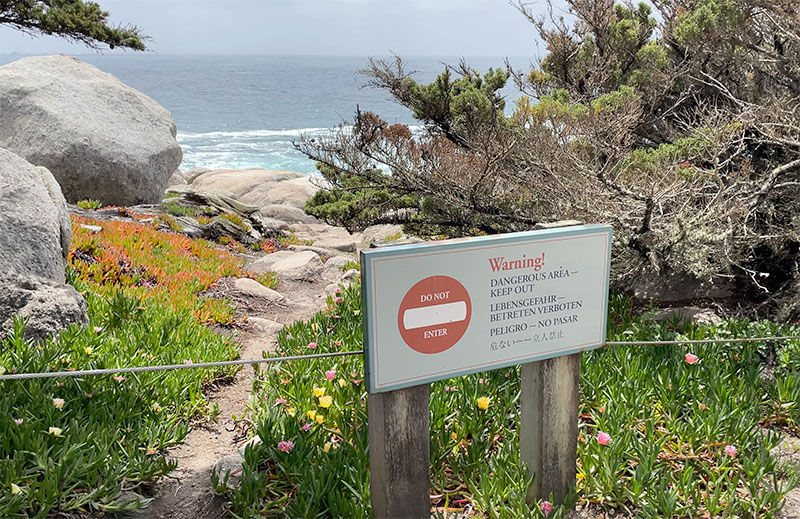
You can walk around a bit here, and even find some spots of solitude, but do be careful about straying off designated pathways. There are signs that warn you about the dynamic nature and dangers of cliff edges, so don’t muck around with hopping into areas over the fence perimeter. It can be tempting because it’s so pretty here, but don’t do it.
A fun fact about Ghost Trees at Pescadero Point - it’s also a legendary big wave surf spot! During powerful winter storms, Pescadero Point is capable of producing waves with faces up to 60 feet (18.3 m) high. Surfing became big here starting in 1960s and boomed in the early 2000s, when surfers started using jet skis to reach huge waves that were otherwise too large and fast to catch under human power. Big wave surfing declined here in the late 2000s, due to the death of a local surfer and new federal restrictions on jet ski use in the Monterey Bay National Marine Sanctuary. Surfing here isn’t banned, but attempts nowadays are very rare. The conditions are just too rough.

Stop 14 - Pebble Beach Visitor Center
This stop brings us back into the manmade realm, to the new Pebble Beach Visitor Center, which opened in 2018. Located across from The Lodge at Pebble Beach, this is a worthwhile stop that many visitors overlook if they don’t want to use any of the facilities. The visitor’s center is a great opportunity though to learn more about Pebble Beach history. In here you’ll find old photographs, exhibits, displays, and interactive maps. The essentials are here too, in case you want to pick up souvenirs, use the restroom, or get a quick snack. There’s also an outdoor patio here, with Adirondack chairs that look out over the ocean. The visitor's center opens daily at 8 am, with a 6 pm weekday closure and 7 pm on weekends.

Stop 15 - Pebble Beach Golf Links
Built by amateur golfers Jack Neville and Douglas Grant in 1919, Pebble Beach Golf Links is one of the world’s most celebrated and iconic golf courses and is ranked as the no.1 public golf course in the United States. It’s famous for its gorgeous oceanfront holes and long championship pedigree. Pebble Beach Golf Links has hosted many championships during its storied 100 plus year history, and will be once again hosting the US Open in 2027.

I’m not at all a golf fan - I know next to nothing about the sport. But even I know this course, and I do think it’s worth popping by the entrance to peek in, even if you’re not much into the golf scene. To see more of the course, you don’t have to book a tee time - there are a few public viewing areas around The Lodge. There are several other golf courses in the Pebble Beach resort area as well, so plenty of options to play!

Stop 16 - The Hay
Stop 16 is also about golf. Opened in 1957, The Hay was designed as a short, approachable golf course - one where players of all different skill levels could easily participate. The Hay is a much less intimidating option than the championship level Pebble Beach Golf Links next door. In 2021, Tiger Woods redesigned the course, transforming The Hay into a more modern short course whose second hole is an exact replica of the famous 7th hole at Pebble Beach Golf Links, which is one of the most photographed golf holes in the world.

Stop 17 - Ford Meadow
The final stop on 17-Mile Drive is a quiet one, brining us back inland for a peaceful finale. Ford Meadow is a quiet, open meadow with a rather touching history. It is named after Robert F. Ford, a generous supporter of the Del Monte Forest Conservancy, who had a special connection to this particular piece of land. He always said he knew he was "home" whenever he passed by the meadow, and now the meadow bears his namesake.

Monterey's 17-Mile Drive - Final Thoughts
With stop 17 complete, we've reached the end of our journey along one of California's most beautiful coastal drives. From towering Monterey Cypress trees and dramatic ocean overlooks, to secluded beaches and world-famous golf courses, 17-Mile Drive offers a little bit of everything. What makes this drive so special is that no two stops are quite alike, and there really is something beautiful waiting around every turn.
Whether you're visiting for the scenery, the history, the wildlife, or simply the experience of driving along an incredible stretch of coastline, it's easy to see why 17-Mile Drive is such an iconic California experience.
17-Mile Drive - The Video!
To get more of a feel for what it’s like to drive this incredible road, check out my video tour!
See More of Monterey!
17-Mile Drive was part of an amazing weekend I spent in the Monterey area. While I was here, I also did an incredible whale watching tour (featuring a young humpback who breached nonstop for over 2 hours!) and visited the Monterey Bay Aquarium, which is widely regarded as one of the best in the United States and heavily features animals found right here in the waters around 17-Mile Drive. I’ve got a full guide to the aquarium and a video on the experience as well.


Comments